Archaeologists in Switzerland’s canton of Thurgau have confirmed the presence of a previously unrecorded castle site dating to the 10th and 11th centuries, after an enthusiast spotted unusual earthworks on a high-resolution LiDAR relief map.
The find is in the Töbeli area near Uesslingen-Buch, located in northeastern Switzerland. It sits just under a kilometre west of the Ittingen Charterhouse — a proximity that immediately raises bigger questions about medieval power, monastic foundations, and a castle that historical sources mention but never precisely locate.
The discovery began when Heinz Moll of Ittigen—described as an avid castle researcher—was examining Thurgau’s detailed LiDAR terrain model. He noticed two small plateaus in Töbeli, each ringed by steep ditches, along with several sunken lanes. These features are characteristic of motte-and-bailey castles, also known as earthworks, an early form of medieval fortification built largely from timber and earth.
Moll reported the observation to the Thurgau cantonal archaeology office, which then arranged an officially authorised survey by volunteer searcher Adrian Schoch. After a five-hour metal-detector search, Schoch recovered a small ceramic shard and several iron objects—including three medieval arrowheads. Based on their shape, the arrowheads are dated to the 11th or 12th century, providing the key material evidence that the earthworks are genuinely medieval.
Why Töbeli matters: the missing Ittingen castle
Three medieval iron projectile points from the Töbeli castle site. Photo courtesy Thurgau Office of Archaeology
The Thurgau Office of Archaeology describes the discovery as “of great historical interest,” largely because it intersects with a long-running local question: where exactly was the castle of the Lords of Ittingen located in the 11th and 12th centuries?
According to historical sources referenced in the announcement, the Ittingen Charterhouse (originally an Augustinian Canons Regular monastery) was built on the site of the Lords of Ittingen’s castle. Yet medieval documents do not clearly state where that castle stood—especially after it was reportedly destroyed and later rebuilt.
One document dated 1079 records a conflict between Abbot Eckehard II of Reichenau and Abbot Ulrich III of St. Gallen, during which Ittingen Castle was said to have been razed. Later documents indicate it was rebuilt—but the sources fall silent on the location of that rebuilt stronghold.
When written records stop, archaeology sometimes takes over. Researchers have been looking for traces in the landscape for more than a century, and the new Töbeli identification adds weight—and new complexity—to the search.
Competing sites and a landscape of possibilities
Ittingen Charterhouse – Wikimedia Commons
The announcement notes that there are now three possible locations for the ancestral seat of the Lords of Ittingen. One candidate is a castle site in the Chrüzbuck area in the municipality of Warth-Weiningen, about 350 metres south of Töbeli. Another theory places the castle within the Ittingen Charterhouse itself, drawing on a document of 1152 in which Pope Eugene III granted the brothers Albert, Berchtold, and Ulrich von Ittingen permission to build a monastery on their castle grounds at Ittingen.
Töbeli’s significance, then, is not simply that it represents an early medieval stronghold—but that it may help clarify whether the Ittingen castle tradition refers to one site, multiple phases, or multiple neighbouring fortifications whose functions changed over time.
A castle tied to roads, river crossings, and regional movement
18th-century drawing of Ittingen Charterhouse – Wikimedia Commons
Although today the Chrüzbuck and Töbeli sites are not positioned on major transport routes, the announcement stresses that medieval movement across the landscape looked very different.
In the Middle Ages, a sunken lane ran directly from Töbeli down to the Chrüzbuck site. An east–west route also followed the northern Thur terrace, linking two river crossings—one near Uesslingen and another southeast of the Ittingen Charterhouse. In other words, the newly identified castle was plugged into the regional road network, and may even have stood on a longer-distance corridor between Winterthur and Constance.
That transport context matters because early medieval earthwork castles often gained their importance not just from local lordship, but from their relationship to routes, crossings, and the movement of people and goods.
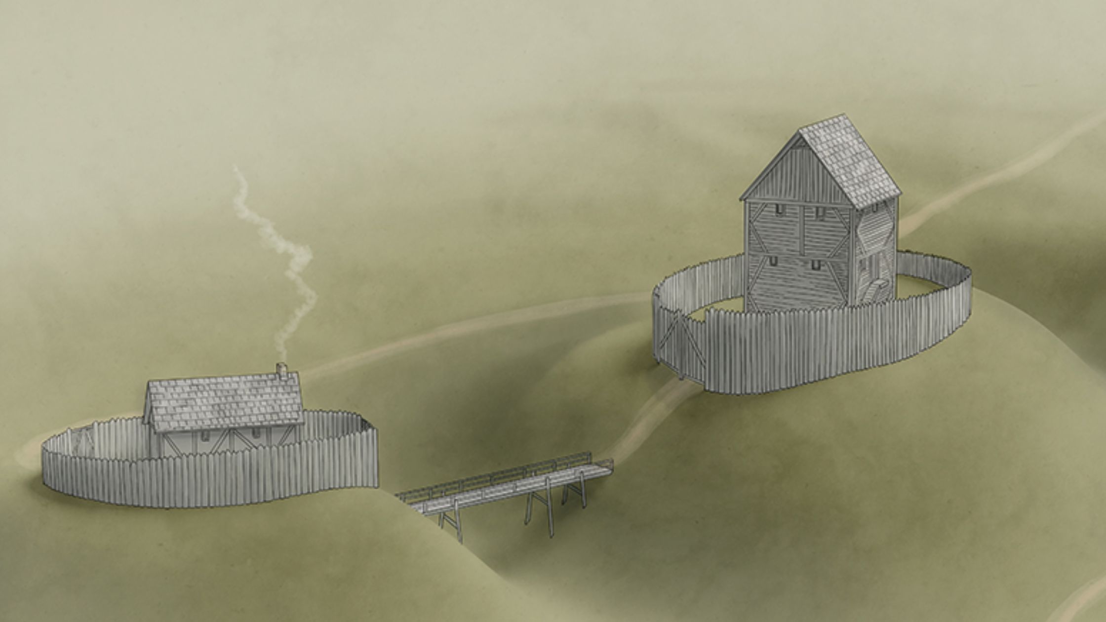
What Töbeli may have looked like
This is what the newly discovered medieval castle site of Töbeli might have looked like. Photo courtesy Thurgau Office of Archaeology
No excavation is planned, but the Thurgau archaeologists offer a plausible reconstruction based on comparable sites. Töbeli may have featured a multi-storey wooden tower, defended by a palisade and deep ditches—a fortification style suited to rapid construction and effective local control, even if little survives above ground today.
The Thurgau Office of Archaeology says it will not excavate the two newly discovered plateaus. Any structures and finds will remain in the ground, preserved for future research methods and questions. Meanwhile, the artefacts recovered during the authorised survey are being conserved and restored at the Office of Archaeology.
Archaeologists in Switzerland’s canton of Thurgau have confirmed the presence of a previously unrecorded castle site dating to the 10th and 11th centuries, after an enthusiast spotted unusual earthworks on a high-resolution LiDAR relief map.
The find is in the Töbeli area near Uesslingen-Buch, located in northeastern Switzerland. It sits just under a kilometre west of the Ittingen Charterhouse — a proximity that immediately raises bigger questions about medieval power, monastic foundations, and a castle that historical sources mention but never precisely locate.
The discovery began when Heinz Moll of Ittigen—described as an avid castle researcher—was examining Thurgau’s detailed LiDAR terrain model. He noticed two small plateaus in Töbeli, each ringed by steep ditches, along with several sunken lanes. These features are characteristic of motte-and-bailey castles, also known as earthworks, an early form of medieval fortification built largely from timber and earth.
Moll reported the observation to the Thurgau cantonal archaeology office, which then arranged an officially authorised survey by volunteer searcher Adrian Schoch. After a five-hour metal-detector search, Schoch recovered a small ceramic shard and several iron objects—including three medieval arrowheads. Based on their shape, the arrowheads are dated to the 11th or 12th century, providing the key material evidence that the earthworks are genuinely medieval.
Why Töbeli matters: the missing Ittingen castle
The Thurgau Office of Archaeology describes the discovery as “of great historical interest,” largely because it intersects with a long-running local question: where exactly was the castle of the Lords of Ittingen located in the 11th and 12th centuries?
According to historical sources referenced in the announcement, the Ittingen Charterhouse (originally an Augustinian Canons Regular monastery) was built on the site of the Lords of Ittingen’s castle. Yet medieval documents do not clearly state where that castle stood—especially after it was reportedly destroyed and later rebuilt.
One document dated 1079 records a conflict between Abbot Eckehard II of Reichenau and Abbot Ulrich III of St. Gallen, during which Ittingen Castle was said to have been razed. Later documents indicate it was rebuilt—but the sources fall silent on the location of that rebuilt stronghold.
When written records stop, archaeology sometimes takes over. Researchers have been looking for traces in the landscape for more than a century, and the new Töbeli identification adds weight—and new complexity—to the search.
Competing sites and a landscape of possibilities
The announcement notes that there are now three possible locations for the ancestral seat of the Lords of Ittingen. One candidate is a castle site in the Chrüzbuck area in the municipality of Warth-Weiningen, about 350 metres south of Töbeli. Another theory places the castle within the Ittingen Charterhouse itself, drawing on a document of 1152 in which Pope Eugene III granted the brothers Albert, Berchtold, and Ulrich von Ittingen permission to build a monastery on their castle grounds at Ittingen.
Töbeli’s significance, then, is not simply that it represents an early medieval stronghold—but that it may help clarify whether the Ittingen castle tradition refers to one site, multiple phases, or multiple neighbouring fortifications whose functions changed over time.
A castle tied to roads, river crossings, and regional movement
Although today the Chrüzbuck and Töbeli sites are not positioned on major transport routes, the announcement stresses that medieval movement across the landscape looked very different.
In the Middle Ages, a sunken lane ran directly from Töbeli down to the Chrüzbuck site. An east–west route also followed the northern Thur terrace, linking two river crossings—one near Uesslingen and another southeast of the Ittingen Charterhouse. In other words, the newly identified castle was plugged into the regional road network, and may even have stood on a longer-distance corridor between Winterthur and Constance.
That transport context matters because early medieval earthwork castles often gained their importance not just from local lordship, but from their relationship to routes, crossings, and the movement of people and goods.
What Töbeli may have looked like
No excavation is planned, but the Thurgau archaeologists offer a plausible reconstruction based on comparable sites. Töbeli may have featured a multi-storey wooden tower, defended by a palisade and deep ditches—a fortification style suited to rapid construction and effective local control, even if little survives above ground today.
The Thurgau Office of Archaeology says it will not excavate the two newly discovered plateaus. Any structures and finds will remain in the ground, preserved for future research methods and questions. Meanwhile, the artefacts recovered during the authorised survey are being conserved and restored at the Office of Archaeology.
Subscribe to Medievalverse
Related Posts