Want to zoom into a set of enormous historical maps and trace the Ryukyu Islands coastline by coastline, island by island? The University of Tokyo has made the Ryukyu Kuniezu available through a high-resolution digital viewer, allowing anyone to explore these vast charts in remarkable detail—right down to individual place names and fine cartographic features.
The Ryukyu Kuniezu consists of three large hand-drawn maps depicting the Ryukyu Kingdom and its island groups. Dating to the 17th century, each map measures several metres across, making them difficult to display or study in person. In digital form, however, their scale becomes an advantage rather than an obstacle. Users can pan smoothly across the islands, zoom in to inspect coastal inlets and settlements, and shift instantly from a wide regional view to close examination of small details.
Researchers spread an old map of Ryukyu in an exhibition room at the National Museum of Japanese History in Sakura, Chiba Prefecture, before it is scanned. Photo courtesy of Satoru Kuroshima
The maps present the Ryukyu Islands as a connected maritime world. Long chains of islands stretch across the sea between southern Japan and Taiwan, with Okinawa at the centre. The careful rendering of coastlines and the spacing between islands give a clear sense of how geography shaped political and economic life. Even without reading every label, viewers can see how certain areas are emphasised, how shorelines were understood, and how the kingdom visualised its own territory.
The Ryukyu Kingdom itself took shape in the late medieval era. In 1429, Okinawa was unified under a single ruler, creating a kingdom centred at Shuri. From there, Ryukyu developed into a maritime trading state linking Japan, China, Korea, and Southeast Asia. Through tributary ties with Ming China and extensive seaborne commerce, it prospered as a diplomatic and commercial intermediary for centuries.
Detail from one of the Ryukyu Kuniezu maps
The maps were digitised by the Historiographical Institute at the University of Tokyo. Professor Satoru Kuroshima, who headed the project, explains his team “made it their mission to make accurate copies of historical materials by traveling to places where the originals of such materials are preserved. In recent years, we have worked to digitize the materials and make their images public.”
A scene of Ming dynasty soldiers battling Japanese pirates known as Wako in Wako Zukan, a picture scroll made in 17th-century China. Image by the Historiographical Institute, CC BY 4.0
Alongside the Ryukyu maps, the institute has also made available another large-scale work: Wako Zukan, a picture scroll depicting Japanese pirates active along the coasts of China and Korea. The scroll, which extends over five metres, also dates to the 17th century. Together, the maps and the scroll demonstrate how oversized historical materials—once difficult to consult—can now be explored in depth by anyone with an internet connection.
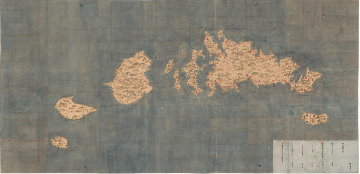
Top Image: A map of the Ryukyu Kingdom, which measures 3.5 meters by 7.3 meters, can be viewed in detail through the digital archive on the Historiographical Institute’s website. The archive allows users to overlay the old map with a contemporary map of Okinawa. Image by the Historiographical Institute, CC BY 4.0
Want to zoom into a set of enormous historical maps and trace the Ryukyu Islands coastline by coastline, island by island? The University of Tokyo has made the Ryukyu Kuniezu available through a high-resolution digital viewer, allowing anyone to explore these vast charts in remarkable detail—right down to individual place names and fine cartographic features.
The Ryukyu Kuniezu consists of three large hand-drawn maps depicting the Ryukyu Kingdom and its island groups. Dating to the 17th century, each map measures several metres across, making them difficult to display or study in person. In digital form, however, their scale becomes an advantage rather than an obstacle. Users can pan smoothly across the islands, zoom in to inspect coastal inlets and settlements, and shift instantly from a wide regional view to close examination of small details.
The maps present the Ryukyu Islands as a connected maritime world. Long chains of islands stretch across the sea between southern Japan and Taiwan, with Okinawa at the centre. The careful rendering of coastlines and the spacing between islands give a clear sense of how geography shaped political and economic life. Even without reading every label, viewers can see how certain areas are emphasised, how shorelines were understood, and how the kingdom visualised its own territory.
The Ryukyu Kingdom itself took shape in the late medieval era. In 1429, Okinawa was unified under a single ruler, creating a kingdom centred at Shuri. From there, Ryukyu developed into a maritime trading state linking Japan, China, Korea, and Southeast Asia. Through tributary ties with Ming China and extensive seaborne commerce, it prospered as a diplomatic and commercial intermediary for centuries.
The maps were digitised by the Historiographical Institute at the University of Tokyo. Professor Satoru Kuroshima, who headed the project, explains his team “made it their mission to make accurate copies of historical materials by traveling to places where the originals of such materials are preserved. In recent years, we have worked to digitize the materials and make their images public.”
Alongside the Ryukyu maps, the institute has also made available another large-scale work: Wako Zukan, a picture scroll depicting Japanese pirates active along the coasts of China and Korea. The scroll, which extends over five metres, also dates to the 17th century. Together, the maps and the scroll demonstrate how oversized historical materials—once difficult to consult—can now be explored in depth by anyone with an internet connection.
Click here to explore the Ryukyu Kuniezu maps
Click here to explore the Wako Zukan
Top Image: A map of the Ryukyu Kingdom, which measures 3.5 meters by 7.3 meters, can be viewed in detail through the digital archive on the Historiographical Institute’s website. The archive allows users to overlay the old map with a contemporary map of Okinawa. Image by the Historiographical Institute, CC BY 4.0
Subscribe to Medievalverse
Related Posts