
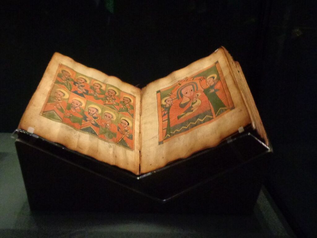
Medieval Manuscripts: A Walk through 16th century Constantinople, Baghdad, and Aleppo
Do you want to see the 16th century Middle East through an illuminator’s eyes? Check out the interactive maps!

Mental Geographies and Cultural Identities in the Baltic Region in the Eleventh-Century: the Anglo-Saxon Cotton World Map
The cartography of the Baltic Sea and Scandinavia has been an interesting topic among scholars of the history of the ancient maps.
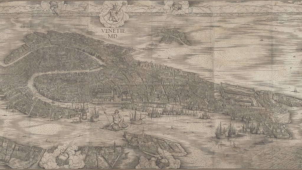
Jacopo de’ Barbari’s ‘View of Venice’ (1500): Image Vehicles Past and Present
This essay focuses on an iconic and ground-breaking woodcut – Jacopo de’ Barbari (c. 1460/70–1516) and Anton Kolb’s View of Venice (1500) – and an interactive museum installation that I first developed for Duke University’s Nasher Museum of Art.

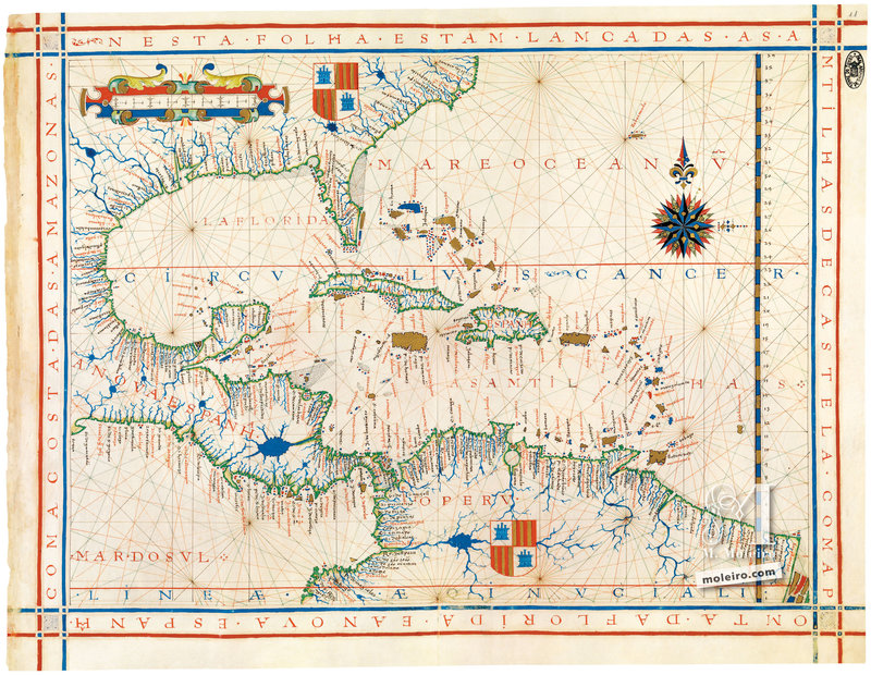
500 Years after the First Voyage around the World: Secrets of the Atlas Miller
This is the secret of the Atlas Miller: it tries to counter the idea that the world could be circumnavigated.

Portolan Charts from the Late Thirteenth Century to 1500
From the earliest extant copies, probably a little before 1300, the outline they gave for the Mediterranean was amazingly accurate.
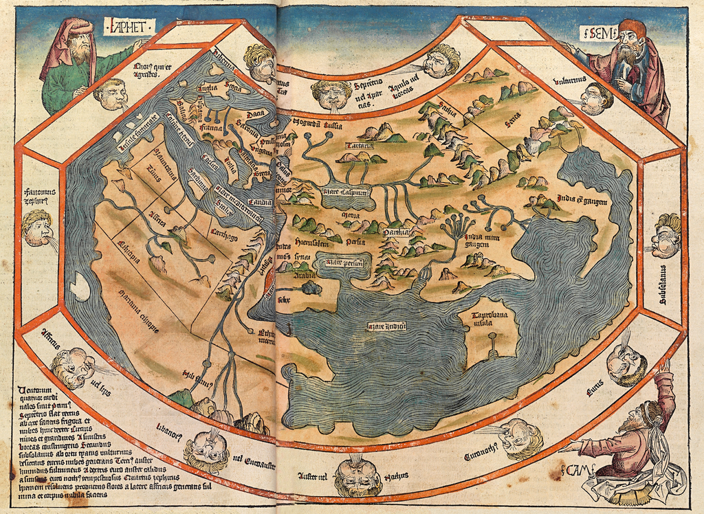
Geographies of Salvation: How to Read Medieval Mappae Mundi
Scholars who judge mappae mundi by medieval standards usually emphasize the salvific over the practical aspect. But were mappae mundi truly not ‘realistic’?
Maps, Monsters and Misericords: From Creation to Apocalypse
This survey of maps and misericords suggests that the other has persistently been envisioned as strange and threatening and thus a constant challenge that tests morality.
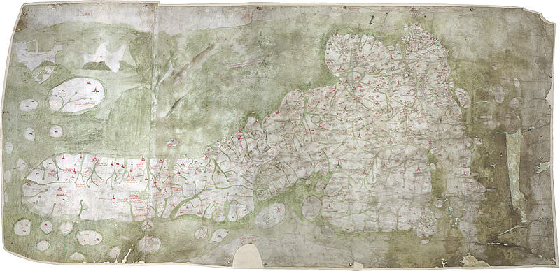
The Date of the Gough Map
The date commonly given for the Gough map of Britain, about 1360, is, in the author’s opinion, wrong. Arguments that have been offered to support such a dating are invalid.
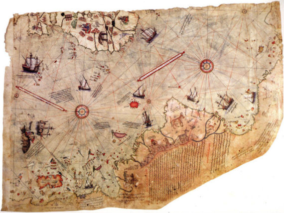
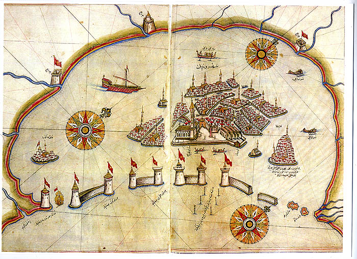
The Piri Reis Map of 1528: A Comparative Study with Other Maps of the Time
The second world map by Piri Reis, made in 1528, as with his earlier world map of 1513, is only a remnant of a larger world map no longer extant. And, as with the first map, the surviving portion preserves areas depicting the newly discovered lands to the west of Europe.
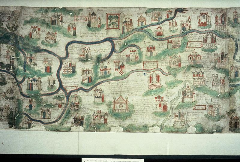
Pilgrimage, Cartography, and Devotion: William Wey’s Map of the Holy Land
This article offers a reconstruction of a chapel, set up in England in the 1470s to commemorate a pilgrimage to the Holy Land. The reconstruction follows information drawn from the founder’s will.
Dialect in the Viking-Age Scandinavian diaspora: the evidence of medieval minor names.
This thesis aims to investigate the Scandinavian contribution to medieval microtoponymic vocabulary in two areas of northwest England, and it attempts to clarify what Scandinavian-derived place-name elements in minor names can tell us.
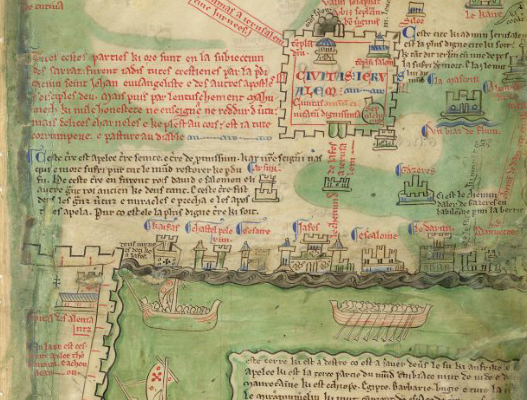
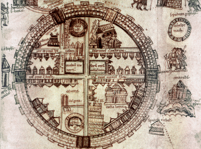
The Oxford map of Palestine in the work of Matthew Paris
He was long-winded, opinionated, cranky, and interested in everything. He moves from politics at court, to the abuses of ecclesiastical power, to foreign relations, to peculiar meteorological and astronomical occurrences, to uncanny incidents.

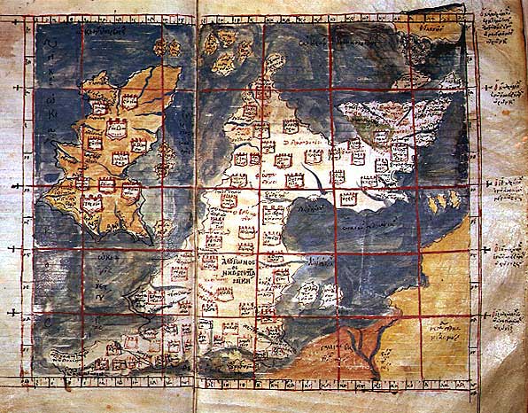
Mapping the World in Medieval China
This talk looks at the extent of geographic and cartographic knowledge of the world that existed in medieval China.
Maps, Travel and Exploration in the Middle Ages: Some Reflections about Anachronism
How were maps conceived in the Middle Ages? Using the words “map”, “travel” and “exploration”, historians must be wary of anachronism.
The Global Side of Medieval at the Getty Centre: Traversing the Globe Through Illuminated Manuscripts
Los Angeles correspondent, Danielle Trynoski takes through the, ‘Traversing the Globe Through Illuminated Manuscripts’ exhibut at the Getty Museum.

Unknown Europe: The Mapping of the Northern countries by Olaus Magnus in 1539
Olaus Magnus, a highly educated Swedish priest and scholar, published his geographically and ethnographically remarkable map of the Northern countries, the Carta marina, in Venice in 1539.

Mapping a New View of the Medieval World
Maps do more than show us the way and identify major landmarks – rivers, towns, roads and hills. For centuries, they also offered a perspective on how societies viewed themselves in comparison to the rest of the world.

Sea Monsters on Medieval and Renaissance Maps
Chet Van Duzer, author of the recent book Sea Monsters on Medieval and Renaissance Maps, will trace the history of sea monsters on European maps, beginning with the earliest mappaemundi on which they appear in the tenth century and continuing to the end of the sixteenth century.
Medieval Manuscripts: The Universal Atlas of Fernão Vaz Dourado
Vaz Dourado authored at least four different nautical atlases, each of them including 20 maps, painted between 1568 and 1580, which is to say at the pinnacle of Portuguese cartography.

Medieval Maps of Britain
How did people depict England, Scotland and Wales in the Middle Ages? Here are 15 images of maps created between the 11th and 16th centuries, which shows how maps developed over history.

Recovering the lost details of a medieval map
Researchers at Yale University have started a project to recover details from a 15th-century world map which had been obscured after centuries of fading.

The Ebstorf Map: tradition and contents of a medieval picture of the world
The Ebstorf Map, the largest medieval map of the world whose original has been lost, is not only a geographical map.
Quiz: Medieval Maps
How good are your geography skills? Try to identify these 15 places based on how they are depicted in medieval maps

Real and imaginary journeys in the later Middle Ages
For a proper understanding of the actions of men in the past it is necessary to have some idea of how they conceived the world and their place in it, yet for the medieval period there is a serious inbalance in the sources.
