A new Cambridge study marks the 500th anniversary of the first Bible to include a map of the Holy Land—printed in 1525, and printed backwards. Despite this error, the map became one of the most influential innovations in the history of biblical publishing, reshaping how readers imagined sacred geography and, eventually, how people conceptualised political borders.
“This is simultaneously one of publishing’s greatest failures and triumphs,” says Nathan MacDonald, Professor of the Interpretation of the Old Testament at the University of Cambridge. “They printed the map backwards so the Mediterranean appears to the east of Palestine. People in Europe knew so little about this part of the world that no one in the workshop seems to have realised. But this map transformed the Bible forever and today most Bibles contain maps.”
MacDonald’s new research, published in The Journal of Theological Studies, argues that the map—created by Lucas Cranach the Elder and printed in Zürich—did far more than illustrate biblical stories. It helped introduce the idea that territorial lines on a map could represent distinct, meaningful divisions.
A Backwards Map That Remade the Bible
Professor Nathan MacDonald with Christopher Froschauer’s 1525 Old Testament open at Lucas Cranach the Elder’s map of the Holy Land, in the Wren Library, Trinity College, Cambridge. Photo courtesy University of Cambridge
The 1525 Old Testament printed by Christopher Froschauer survives in only a handful of copies worldwide, including one preserved at Trinity College Cambridge’s Wren Library. Within its pages is Cranach’s pioneering Holy Land map, showing the stages of the Israelites’ wilderness wanderings and the division of the Promised Land into the twelve tribal territories.
These territorial lines were rooted in Christian traditions that emphasised inheritances and sacred claims to biblical sites. Cranach drew on medieval precedents and on the 1st-century historian Josephus, who simplified the often contradictory geographical descriptions in the Book of Joshua. As MacDonald notes, “Joshua 13–19 doesn’t offer an entirely coherent, consistent picture of what land and cities were occupied by the different tribes. There are several discrepancies. The map helped readers to make sense of things even if it wasn’t geographically accurate.”
Its publication in Zürich was no accident. A literal reading of the Bible was central to the Swiss Reformation, and maps presented a powerful way to demonstrate that biblical events took place in real, recognisable landscapes. In a period when certain religious images were banned, maps of the Holy Land were permitted—and even encouraged—as tools for devotion.
“When they cast their eyes over Cranach’s map, pausing at Mount Carmel, Nazareth, the River Jordan and Jericho, people were taken on a virtual pilgrimage,” MacDonald explains. “In their mind’s eye, they travelled across the map, encountering the sacred story as they did so.”
MacDonald argues that Cranach’s map deserves a place alongside other major milestones in the Bible’s material history, from the move from scroll to codex, to the creation of the first portable single-volume Bible in the 13th Century, to the later addition of chapters, verses, and poetic layout. “The Bible has never been an unchanging book,” he says. “It is constantly transforming.”
From Sacred Inheritance to Political Borders
The ‘Modern Map of the Holy Land’ from the 1486 (1482) Ulm reprinting of Ptolemy’s Cosmographia (https://purl.stanford.edu/fs844yc9264).
Medieval maps depicting the tribal territories carried spiritual meaning, presenting Christian claims to biblical inheritance. But by the late fifteenth and early sixteenth centuries, MacDonald argues, these lines began migrating from biblical maps into maps of the wider world, where they came to represent something distinctly new: political borders.
“Bible maps delineating the territories of the twelve tribes were powerful agents in the development and spread of these ideas,” MacDonald says. A text that did not describe modern nation-states suddenly appeared to justify dividing the world into distinct sovereign territories. As the Reformation and the printing revolution allowed more people to own Bibles, these mapped borders shaped how readers understood the world—and their place within it.
“Lines on maps started to symbolise the limits of political sovereignties rather than the boundless divine promises,” MacDonald explains. What began as a tool to make sense of biblical geography became part of early modern political thought.
Why It Matters Today
For many, the Bible still plays a role in shaping how they think about nations and borders. MacDonald cites a recent U.S. Customs and Border Protection recruitment video in which an agent quotes Isaiah 6:8 while flying above the US–Mexico border. Such references, he argues, show how modern ideas about state boundaries can be framed—and justified—through biblical language.
“When I asked ChatGPT and Google Gemini whether borders are biblical, they both simply answered ‘yes’. The reality is more complex,” he says. MacDonald warns that treating modern political structures as divinely mandated can oversimplify ancient texts that were addressing very different societies and ideological concerns.
As the first Bible map turns 500, its legacy is still visible—not only in the back pages of modern Bibles but in the ways early modern readers began imagining the world itself.
Nathan MacDonald’s article, “Ancient Israel and the Modern Bounded State,” is published in The Journal of Theological Studies. Click here to read it.
If you are interested in thinking about borders and the Bible, here’s a new article.
It traces a complex history between the Bible and the borders of modern nation states. So it’s relevant to the challenge of Christian nationalism.
Top Image: Lucas Cranach the Elder’s map of the Holy Land in Christopher Froschauer’s Old Testament (Zürich, 1525) in The Wren Library, Trinity College, Cambridge. Image courtesy The Master and Fellows of Trinity College, Cambridge
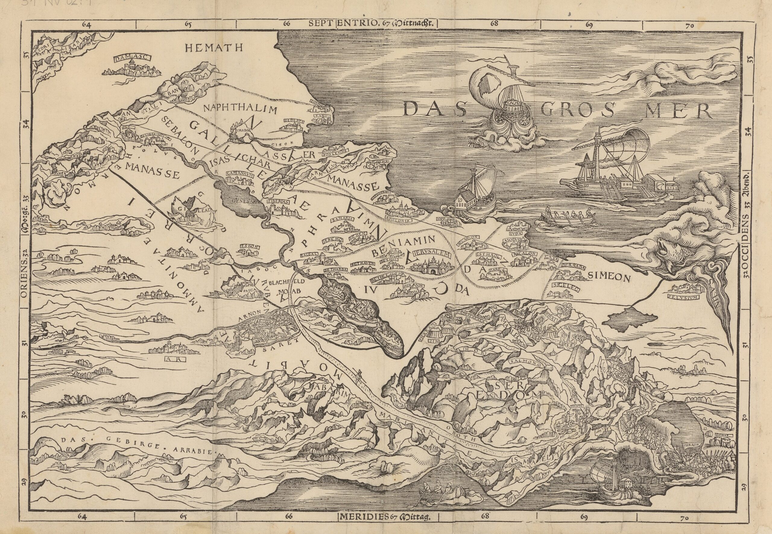
A new Cambridge study marks the 500th anniversary of the first Bible to include a map of the Holy Land—printed in 1525, and printed backwards. Despite this error, the map became one of the most influential innovations in the history of biblical publishing, reshaping how readers imagined sacred geography and, eventually, how people conceptualised political borders.
“This is simultaneously one of publishing’s greatest failures and triumphs,” says Nathan MacDonald, Professor of the Interpretation of the Old Testament at the University of Cambridge. “They printed the map backwards so the Mediterranean appears to the east of Palestine. People in Europe knew so little about this part of the world that no one in the workshop seems to have realised. But this map transformed the Bible forever and today most Bibles contain maps.”
MacDonald’s new research, published in The Journal of Theological Studies, argues that the map—created by Lucas Cranach the Elder and printed in Zürich—did far more than illustrate biblical stories. It helped introduce the idea that territorial lines on a map could represent distinct, meaningful divisions.
A Backwards Map That Remade the Bible
The 1525 Old Testament printed by Christopher Froschauer survives in only a handful of copies worldwide, including one preserved at Trinity College Cambridge’s Wren Library. Within its pages is Cranach’s pioneering Holy Land map, showing the stages of the Israelites’ wilderness wanderings and the division of the Promised Land into the twelve tribal territories.
These territorial lines were rooted in Christian traditions that emphasised inheritances and sacred claims to biblical sites. Cranach drew on medieval precedents and on the 1st-century historian Josephus, who simplified the often contradictory geographical descriptions in the Book of Joshua. As MacDonald notes, “Joshua 13–19 doesn’t offer an entirely coherent, consistent picture of what land and cities were occupied by the different tribes. There are several discrepancies. The map helped readers to make sense of things even if it wasn’t geographically accurate.”
Its publication in Zürich was no accident. A literal reading of the Bible was central to the Swiss Reformation, and maps presented a powerful way to demonstrate that biblical events took place in real, recognisable landscapes. In a period when certain religious images were banned, maps of the Holy Land were permitted—and even encouraged—as tools for devotion.
“When they cast their eyes over Cranach’s map, pausing at Mount Carmel, Nazareth, the River Jordan and Jericho, people were taken on a virtual pilgrimage,” MacDonald explains. “In their mind’s eye, they travelled across the map, encountering the sacred story as they did so.”
MacDonald argues that Cranach’s map deserves a place alongside other major milestones in the Bible’s material history, from the move from scroll to codex, to the creation of the first portable single-volume Bible in the 13th Century, to the later addition of chapters, verses, and poetic layout. “The Bible has never been an unchanging book,” he says. “It is constantly transforming.”
From Sacred Inheritance to Political Borders
Medieval maps depicting the tribal territories carried spiritual meaning, presenting Christian claims to biblical inheritance. But by the late fifteenth and early sixteenth centuries, MacDonald argues, these lines began migrating from biblical maps into maps of the wider world, where they came to represent something distinctly new: political borders.
“Bible maps delineating the territories of the twelve tribes were powerful agents in the development and spread of these ideas,” MacDonald says. A text that did not describe modern nation-states suddenly appeared to justify dividing the world into distinct sovereign territories. As the Reformation and the printing revolution allowed more people to own Bibles, these mapped borders shaped how readers understood the world—and their place within it.
“Lines on maps started to symbolise the limits of political sovereignties rather than the boundless divine promises,” MacDonald explains. What began as a tool to make sense of biblical geography became part of early modern political thought.
Why It Matters Today
For many, the Bible still plays a role in shaping how they think about nations and borders. MacDonald cites a recent U.S. Customs and Border Protection recruitment video in which an agent quotes Isaiah 6:8 while flying above the US–Mexico border. Such references, he argues, show how modern ideas about state boundaries can be framed—and justified—through biblical language.
“When I asked ChatGPT and Google Gemini whether borders are biblical, they both simply answered ‘yes’. The reality is more complex,” he says. MacDonald warns that treating modern political structures as divinely mandated can oversimplify ancient texts that were addressing very different societies and ideological concerns.
As the first Bible map turns 500, its legacy is still visible—not only in the back pages of modern Bibles but in the ways early modern readers began imagining the world itself.
Nathan MacDonald’s article, “Ancient Israel and the Modern Bounded State,” is published in The Journal of Theological Studies. Click here to read it.
Top Image: Lucas Cranach the Elder’s map of the Holy Land in Christopher Froschauer’s Old Testament (Zürich, 1525) in The Wren Library, Trinity College, Cambridge. Image courtesy The Master and Fellows of Trinity College, Cambridge
Subscribe to Medievalverse
Related Posts