A new study published in the Journal of Archaeological Science offers a revealing look at how England’s medieval road network was shaped by the Roman infrastructure that preceded it. By analysing the red lines on the fifteenth-century Gough Map, a richly detailed depiction of Great Britain, the researchers have traced the persistence of Roman roads well into the medieval period, while also identifying key routes that fell out of use.
The researchers, Eljas Oksanen (University of Helsinki) and Stuart Brookes (UCL Institute of Archaeology), created a comprehensive Geographic Information Systems (GIS) database that links the routes shown on the Gough Map to archaeological evidence, medieval place-names, and historical documents.
At the heart of the project is the question of how much of the Roman road network endured after the collapse of imperial authority in Britain. The authors concluded that nearly a third of the red lines visible on the Gough Map can be confidently dated to the Roman period, with another third verified as medieval in origin. The remainder likely existed in the medieval period but lack clear earlier evidence. These figures speak to the longevity of Roman engineering, but also to the dynamic nature of medieval travel and settlement.
The researchers explain:
The results of our analysis show that in the sample of route lengths captured by the Gough Map, almost a third can be securely and independently dated to the medieval period by the aforementioned evidence (e.g., archaeology, place-names, charter boundary clauses). Of the rest, about one third are of known Roman routes (pre-410 CE, some of these having possibly originated as prehistoric trackways). For another third there is no evidence for them predating the Early Modern period (1540–1800 CE), although the Gough Map indicates they were medieval as well. Indeed, it should be noted that each category above ‘Early Modern’ represents the minimum verifiable proportion of routes from that time period as it is possible that, for example, some ‘medieval’ routes are currently unrecognized Roman routes.
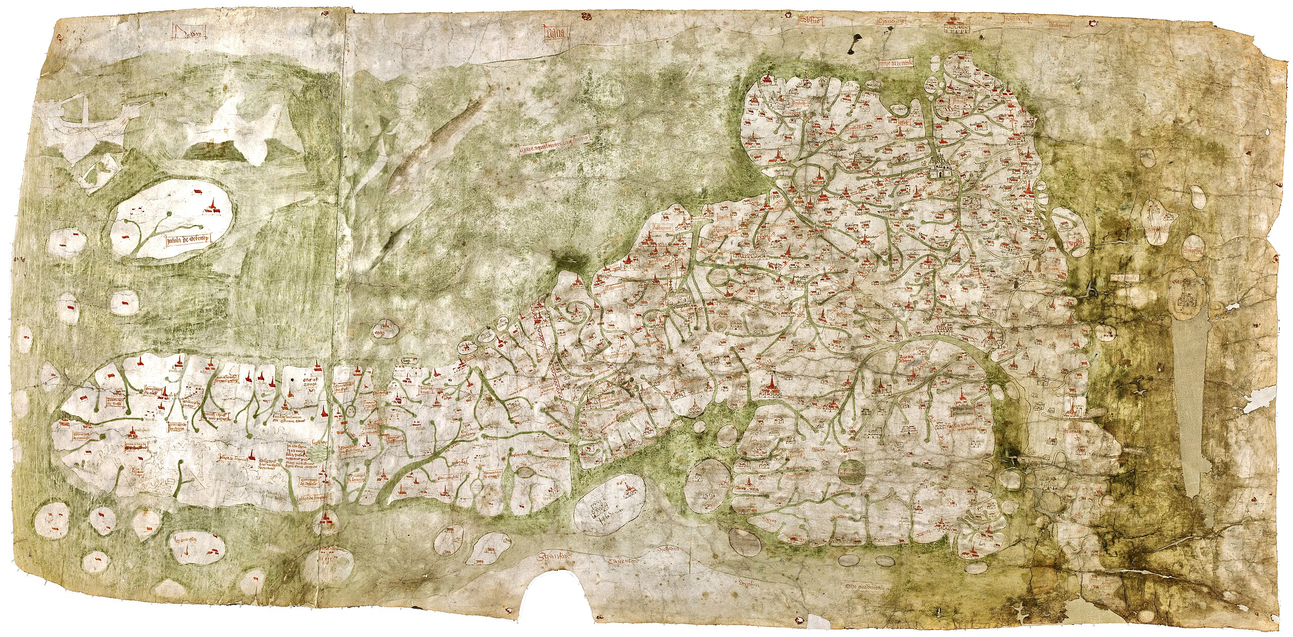
The Gough Map, held at the Bodleian Library in Oxford, is one of the oldest surviving maps of Great Britain. Likely created in the early fifteenth century, it features over 600 settlements and a network of distinctive red lines connecting them. These lines had long been debated among historians, but the study confirms they closely follow real-world transport routes, making the map an invaluable record of late medieval road infrastructure.
This detail of the Gough Map shows several red lines connecting places.
To identify and verify these routes, the researchers employed a mix of qualitative and computational methods. They used datasets of Roman and medieval roads, place-name studies, boundary clauses from Anglo-Saxon charters, and even coin finds recorded by metal detectorists. Thousands of medieval and Roman coins were spatially analysed to determine their proximity to historic roads.
Explaining the Survival of Ancient Roads
The study also reveals why some Roman routes vanished. Political changes in the early medieval period played a key role, particularly the fragmentation of authority into smaller kingdoms and tribal zones following the end of Roman rule. Environmental factors were just as important. Roads that crossed chalk downland, where soil is dry and free-draining, were more likely to be maintained and reused, whereas those on heavy clay soils often fell into disrepair. Changes in farming patterns, especially the rise of enclosed fields in the central provinces, also disrupted earlier lines of travel.
Roads connecting London to other places in England
The authors give special attention to how towns influenced the persistence of ancient roads. They write:
With the abandonment of urban centres in the post-Roman period it is certain that people were no longer accessing towns as frequently as they had in previous centuries, with a corresponding freeing up of town-focused patterns of mobility. Here the survival of Roman roads depended greatly on the afterlives of specific places. For example, near medieval towns such as London, Leicester and Winchester, which occupied the same locations as their Roman predecessors, there is good correspondence between the routes depicted on the Gough Map and earlier Roman roads. By contrast, routes near former Roman towns such as Sorviodunum, beside Old Sarum in Wiltshire and Venta Icenorum, Caistor St Edmund in Norfolk, that were replaced by new towns at Salisbury and Norwich respectively, survive only partially in the modern landscape and do not feature in the Gough Map.
Ultimately, the study paints a nuanced picture of continuity and change. Rather than a complete break with the Roman past, the English landscape of the fifteenth century retained many of its ancient arteries, often subtly reshaped by new patterns of trade, governance, and geography. The roads captured on the Gough Map reflect decisions made over a millennium, not just by kings and engineers but by countless travellers, farmers, and merchants who shaped and reshaped the landscape through use and adaptation.
The authors hope their methods and dataset will provide a model for further historical and archaeological research elsewhere in Europe. By combining old maps, material finds, and modern digital tools, scholars can recover lost geographies—and perhaps rewrite what we thought we knew about movement, memory, and the medieval road.
The article, “The afterlife of Roman roads in England: insights from the fifteenth-century Gough map of Great Britain,” by Eljas Oksanen and Stuart Brookes, appears in the Journal of Archaeological Science. Click here to read it.
A new study published in the Journal of Archaeological Science offers a revealing look at how England’s medieval road network was shaped by the Roman infrastructure that preceded it. By analysing the red lines on the fifteenth-century Gough Map, a richly detailed depiction of Great Britain, the researchers have traced the persistence of Roman roads well into the medieval period, while also identifying key routes that fell out of use.
The researchers, Eljas Oksanen (University of Helsinki) and Stuart Brookes (UCL Institute of Archaeology), created a comprehensive Geographic Information Systems (GIS) database that links the routes shown on the Gough Map to archaeological evidence, medieval place-names, and historical documents.
At the heart of the project is the question of how much of the Roman road network endured after the collapse of imperial authority in Britain. The authors concluded that nearly a third of the red lines visible on the Gough Map can be confidently dated to the Roman period, with another third verified as medieval in origin. The remainder likely existed in the medieval period but lack clear earlier evidence. These figures speak to the longevity of Roman engineering, but also to the dynamic nature of medieval travel and settlement.
The researchers explain:
The results of our analysis show that in the sample of route lengths captured by the Gough Map, almost a third can be securely and independently dated to the medieval period by the aforementioned evidence (e.g., archaeology, place-names, charter boundary clauses). Of the rest, about one third are of known Roman routes (pre-410 CE, some of these having possibly originated as prehistoric trackways). For another third there is no evidence for them predating the Early Modern period (1540–1800 CE), although the Gough Map indicates they were medieval as well. Indeed, it should be noted that each category above ‘Early Modern’ represents the minimum verifiable proportion of routes from that time period as it is possible that, for example, some ‘medieval’ routes are currently unrecognized Roman routes.
The Gough Map, held at the Bodleian Library in Oxford, is one of the oldest surviving maps of Great Britain. Likely created in the early fifteenth century, it features over 600 settlements and a network of distinctive red lines connecting them. These lines had long been debated among historians, but the study confirms they closely follow real-world transport routes, making the map an invaluable record of late medieval road infrastructure.
To identify and verify these routes, the researchers employed a mix of qualitative and computational methods. They used datasets of Roman and medieval roads, place-name studies, boundary clauses from Anglo-Saxon charters, and even coin finds recorded by metal detectorists. Thousands of medieval and Roman coins were spatially analysed to determine their proximity to historic roads.
Explaining the Survival of Ancient Roads
The study also reveals why some Roman routes vanished. Political changes in the early medieval period played a key role, particularly the fragmentation of authority into smaller kingdoms and tribal zones following the end of Roman rule. Environmental factors were just as important. Roads that crossed chalk downland, where soil is dry and free-draining, were more likely to be maintained and reused, whereas those on heavy clay soils often fell into disrepair. Changes in farming patterns, especially the rise of enclosed fields in the central provinces, also disrupted earlier lines of travel.
The authors give special attention to how towns influenced the persistence of ancient roads. They write:
With the abandonment of urban centres in the post-Roman period it is certain that people were no longer accessing towns as frequently as they had in previous centuries, with a corresponding freeing up of town-focused patterns of mobility. Here the survival of Roman roads depended greatly on the afterlives of specific places. For example, near medieval towns such as London, Leicester and Winchester, which occupied the same locations as their Roman predecessors, there is good correspondence between the routes depicted on the Gough Map and earlier Roman roads. By contrast, routes near former Roman towns such as Sorviodunum, beside Old Sarum in Wiltshire and Venta Icenorum, Caistor St Edmund in Norfolk, that were replaced by new towns at Salisbury and Norwich respectively, survive only partially in the modern landscape and do not feature in the Gough Map.
Ultimately, the study paints a nuanced picture of continuity and change. Rather than a complete break with the Roman past, the English landscape of the fifteenth century retained many of its ancient arteries, often subtly reshaped by new patterns of trade, governance, and geography. The roads captured on the Gough Map reflect decisions made over a millennium, not just by kings and engineers but by countless travellers, farmers, and merchants who shaped and reshaped the landscape through use and adaptation.
The authors hope their methods and dataset will provide a model for further historical and archaeological research elsewhere in Europe. By combining old maps, material finds, and modern digital tools, scholars can recover lost geographies—and perhaps rewrite what we thought we knew about movement, memory, and the medieval road.
The article, “The afterlife of Roman roads in England: insights from the fifteenth-century Gough map of Great Britain,” by Eljas Oksanen and Stuart Brookes, appears in the Journal of Archaeological Science. Click here to read it.
Click here to view the Gough Map in depth.
Subscribe to Medievalverse
Related Posts