The Piri Reis Map of 1528: A Comparative Study with Other Maps of the Time
By Gregory C. McIntosh
Mediterranea – Ricerche Storiche, Volume 12, 2015
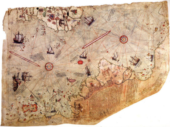
The 1513 map by Piri Reis, Topkapi Museum, Istanbul
Abstract: The second world map by Piri Reis, made in 1528, as with his earlier world map of 1513, is only a remnant of a larger world map no longer extant. And, as with the first map, the surviving portion preserves areas depicting the newly discovered lands to the west of Europe.
A comparison with other contemporary manuscript maps, such as the Turin planisphere (c. 1523), the Freducci chart (c. 1526), and the planispheres produced in the Casa de Contratación, distinguishes certain cartographic design-types of geographical features, such as, Florida, Central America, Newfoundland, and Greenland. The design-types suggest Piri relied upon maps made during the 1520s in Spain by both Spanish cartographers and Portuguese cartographers who worked in Spain for his sources, possibly through the intermediary of Italian-made maps.
Introduction: The famous Ottoman Turkish admiral, Piri Reis (c. 1467 – 1553), who sailed and fought in the seas of both the Mediterranean Basin and the Indian Ocean, is most celebrated for his three great cartographic achievements: 1) the famous Piri Reis manuscript world map of 1513; 2) the Bahriye (also known as Kitab-ı Bahriye), a detailed description with maps of the coasts, islands, and ports of the Mediterranean combining the traditions of the isolario book and the portolano book; and 3) the Piri Reis manuscript world map of 1528. The map of 1528, though not as famous as its older sibling, the map of 1513, merits more study.
The Piri Reis Map of 1528: A Comparative Study with Other Maps of the Time
By Gregory C. McIntosh
Mediterranea – Ricerche Storiche, Volume 12, 2015
Abstract: The second world map by Piri Reis, made in 1528, as with his earlier world map of 1513, is only a remnant of a larger world map no longer extant. And, as with the first map, the surviving portion preserves areas depicting the newly discovered lands to the west of Europe.
A comparison with other contemporary manuscript maps, such as the Turin planisphere (c. 1523), the Freducci chart (c. 1526), and the planispheres produced in the Casa de Contratación, distinguishes certain cartographic design-types of geographical features, such as, Florida, Central America, Newfoundland, and Greenland. The design-types suggest Piri relied upon maps made during the 1520s in Spain by both Spanish cartographers and Portuguese cartographers who worked in Spain for his sources, possibly through the intermediary of Italian-made maps.
Introduction: The famous Ottoman Turkish admiral, Piri Reis (c. 1467 – 1553), who sailed and fought in the seas of both the Mediterranean Basin and the Indian Ocean, is most celebrated for his three great cartographic achievements: 1) the famous Piri Reis manuscript world map of 1513; 2) the Bahriye (also known as Kitab-ı Bahriye), a detailed description with maps of the coasts, islands, and ports of the Mediterranean combining the traditions of the isolario book and the portolano book; and 3) the Piri Reis manuscript world map of 1528. The map of 1528, though not as famous as its older sibling, the map of 1513, merits more study.
Click here to read this article from Storia Mediterranea
Subscribe to Medievalverse
Related Posts